• Logotype for the Route 40 TPMC project, with icons for busses, pedestrians, traffic signals, construction and roadways.
  • Last updated: April 15, 2024

  • Route 40 Transit‑Plus
    Multimodal Corridor (TPMC)

    • Welcome
    • Project
      Overview
    • More About
      TPMC
    • Review Our Designs
      • Westlake
      • Fremont
      • Ballard
      • North Seattle
    • Next Steps
  • Project Design Hub

menu
  • Welcome
  • Project Overview
  • More About TPMC
  • Review Our Designs
  • Westlake
  • Fremont
  • Ballard
  • North Seattle
  • Next Steps

Review the Route 40 Design Updates

  • Westlake Neighborhood Designs
  • Fremont Neighborhood Designs
  • Ballard Neighborhood Designs
  • North Seattle Area Designs

Review the final designs in the Westlake neighborhood

  • Westlake Ave N Freight-and-Bus Only Lanes
  • Westlake Ave N and 9th Ave N
  • Westlake Ave N and Halladay St
  • Bus stops on Westlake Ave N between Crockett St and Galer St
Westlake Ave N Freight-and-Bus Only Lanes

Cross-Section: Westlake Ave N FAB Lanes

Two cross-sections are shown comparing existing conditions and proposed conditions. Existing conditions include two general purpose lanes in each direction. Proposed conditions include one general purpose lane and one freight and bus lane in each direction. The total number of lanes for both options remains four lanes.

Click image to enlarge.

To keep freight moving along Westlake Ave N, a major truck street, new “Freight-and-Bus only lanes” (FAB lanes) are being piloted. People driving freight vehicles over 26,000 pounds (about the size of a garbage truck, large box truck, or semi-truck) can use them.

The FAB lanes will be piloted for one year starting in 2025 to study how effective the shared lanes will be. After the trial period ends, the traffic data collected during the pilot will be reviewed by the third-party Urban Freight Lab. Input from people driving freight vehicles and community members will be considered to determine if the FAB lanes should be installed permanently along Westlake Ave N. If the pilot is successful, FAB lanes may be added to our toolbox for other Seattle streets. More details will be shared via our project email updates and the SDOT blog.

To see where FAB lanes will be installed on Westlake Ave N, please view the project map on the Project Overview page.

Image showing bus driving on lane labeled bus and trucks only.

Example of a freight-and-bus only lane in New York City on 14th St. We are proposing FAB lanes in select parts of Westlake Ave N.

Overview of improvements
  • Convert one northbound travel lane on Westlake Ave N to a FAB lane between Aloha St and where the Aurora Bridge crosses over Westlake Ave N
  • Convert one southbound travel lane on Westlake Ave N to a FAB lane between Blaine St and Aloha St
  • Travel lanes on the Fremont Bridge remain the same as today
  • Access to businesses and driveways will be maintained
Why make these updates?

SDOT’s traffic analysis shows that the FAB lane helps keep freight moving along Westlake Ave N, decreases bus travel time, and has little impact to general purpose traffic. Once the FAB lane is installed, people driving can enter the lanes to make right turns into driveways, parking lots, and at intersections.

Westlake Ave N and 9th Ave N

Plan view drawing of Westlake Ave N and 9th Ave N
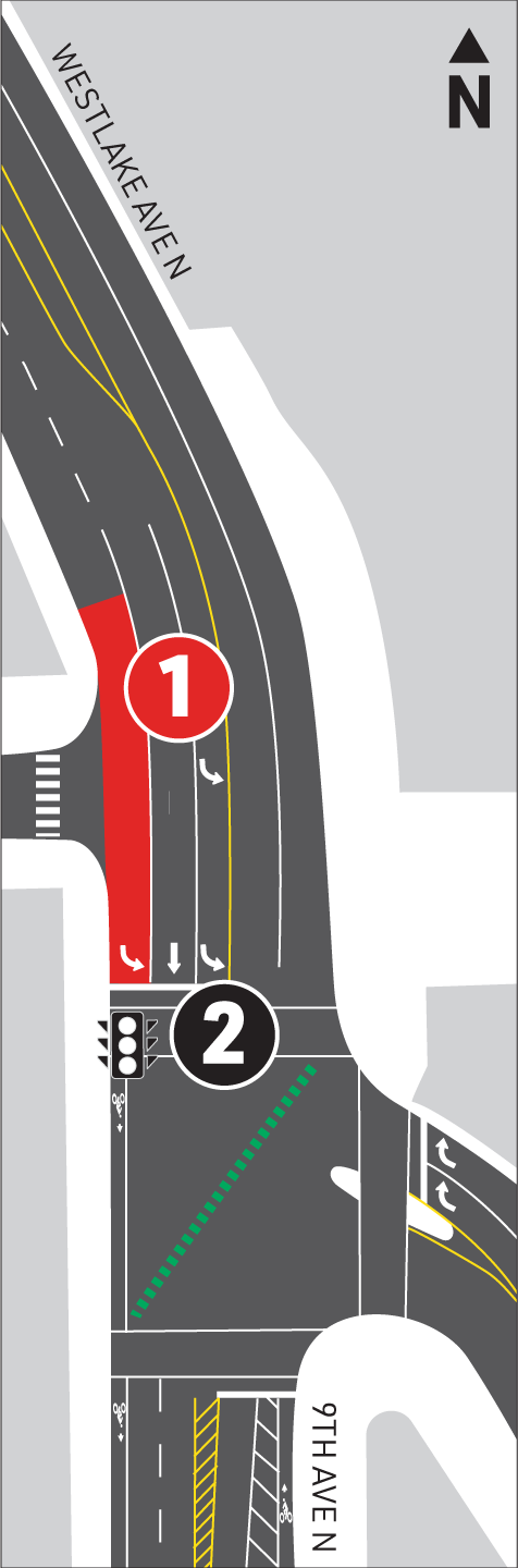
An aerial graphic shows the intersection of Westlake Avenue North and 9th Avenue North. For southbound traffic, the proposed channelization (street layout) is as follows: the curbside lane is now a general purpose through lane, the next lane is now a general purpose left turn lane, and the leftmost lane is now a bus-only left turn lane with a designated signal.

Click image to enlarge.

Legend:

1Bus only left-turn lane

2New turn signal only for buses

Cross-Section: Westlake Ave N and 9th Ave N

Streetmix of  Westlake Ave N and 9th Ave N

Click image to enlarge.

A new southbound bus only left turn lane and a bus only signal are being added at this intersection.

Overview of improvements
  • Maintain the left-turn lane and middle through lane to match existing conditions
  • Convert the westernmost traffic lane (by the curb) to a bus only left turn lane
  • Add a designated bus only turn signal for Route 40 buses to continue onto Westlake Ave N towards Mercer St
Why make these updates?

In 2023, the project team observed the existing conditions at this intersection and found that buses may currently experience some difficulty merging into the existing turn lane. Therefore, to ensure that buses move through this area smoothly, the project team has decided to move the bus only turn lane back to the curbside lane. This design is similar to what was shared with the community in 2021.

Westlake Ave N and Halladay St

Plan view drawing of Westlake Ave N and Halladay St

An aerial graphic shows the intersection of Westlake Avenue North and North Halladay Street. For southbound traffic, the proposed channelization (street layout) is as follows: the curbside lane is now a freight and bus lane, the next lane is now a general purpose lane. For northbound traffic, the proposed channelization (street layout) is as follows: the curbside lane is now a freight and bus lane, the next lane is now a general purpose lane. A new signalized crosswalk is added to the North of Halladay Street. The new bus stop will require parking spots to be removed

Click image to enlarge.

Legend:

1Load zone

2New signalized crosswalk

Cross-Section: Westlake Ave N and Halladay St

Streetmix of  Westlake Ave N and Halladay St

Click image to enlarge.

Based on community feedback, a new signalized pedestrian crossing and new curb ramps are being added at Westlake Ave N and N Halladay St. A new Route 40 bus stop will also be added in both the northbound and southbound directions. The new northbound bus stop will replace the northbound bus stop 26840 currently located between Halladay St and the Fremont Bridge.

A new center turn lane will be installed along Westlake Ave N between the Aurora Bridge and Blaine St. A commercial loading zone will also be installed near N Halladay St.

Overview of improvements
  • New signalized crosswalk just north of N Halladay St
  • New curb ramps
  • Push-activated pedestrian crossing signal
  • New northbound bus stop platform for Route 40 with lighting and a bus shelter
  • New southbound bus stop
  • New two-way center turn lane between the Aurora Bridge and Blaine St
  • New commercial loading zone near N Halladay St
  • New parallel parking behind the northbound bus stop
Why make these updates?

Improvements at this intersection increase safety and access to the new bus stops and the existing Westlake area businesses. These bus stop locations better serve businesses, employees, and residents compared to the existing bus stop. Included is a new crosswalk and new ADA ramps to ensure travelers can safely access this bus stop and the surrounding businesses.

Loading and unloading will also be easier for the surrounding businesses at N Halladay St. A new dedicated loading zone will help support the businesses in the area and enhance predictability for people driving on Westlake Ave N.

Bus stop removal on Westlake Ave N between Crockett St and Galer St

As part of final design, King County Metro has decided to remove the bus stop between Crockett St and Galer St.

In 2023, Metro evaluated accessibility, ridership, and stop spacing for the existing stop across the street from the Q13 Fox building between Crockett St and Galer St. Metro found that ridership at these stops was relatively low compared to other nearby stops on Westlake Ave N. Additionally, these stops lack a crossing for people walking or rolling and there are ADA accessibility challenges at the northbound stop which further contributed to Metro’s decision to remove these stops. Riders should use the stops at 8th Ave N near Galer St or at Westlake Ave N and Crockett St.

Bus stop removal on Westlake Ave N near Q13 Fox headquarters

Image shows the bus stops at 8th Ave N from street view

 
Next Page Previous Page

  • Contact Us:

    For more information, please contact:
    Route40@seattle.gov | (206) 775-8731

    For additional project information, visit our project webpage:
    www.seattle.gov/transportation/Route40

  • Share this website:

  • Logo for Seattle Department of Transportation (SDOT)

    Logo for Move Seattle

    Logo for King County Metro

  • Powered by:

    InfoCommunity logo

    © S&A COMMUNICATIONS, ALL RIGHTS RESERVED 2023